50 Best Hikes in New Zealand: The Ultimate North to South Island Hiking Guide
By Ryan Brown published on 8 June 2026
New Zealand is made for hiking. From volcanic crossings and coastal tracks to alpine ridgelines, glacier valleys, beech forest, waterfalls and multi-day Great Walks, the country packs a huge range of trails into two islands.
But how can you find the best ones for your trip? Don't sweat it, this guide covers 50 of the best hikes in New Zealand, ordered from the North Island to the South Island and grouped by difficulty. Each hike, we've included the distance, route type, estimated time and difficulty, so you can plan around your fitness level, travel route and how much time you have.
Before you go, always check current track conditions with DOC or the local tourism board. Weather, slips, snow, river levels and bridge work can change New Zealand hiking trails quickly, especially in alpine areas.
The Department of Conservation classifies New Zealand walking and tramping tracks by skill, fitness and terrain, from short walks through to expert routes. So we have too to make it easy and consistent. One thing before we hit the trails: In New Zealand, “tramping” is commonly used for hiking, especially on longer or more remote tracks. Let's set off.
Best Easy Hikes in the North Island
1. Rangitoto Summit Track, Auckland
Distance: Estimated 2 hours return
Route type: Return
Difficulty: Easy to medium
Rangitoto is one of Auckland’s most recognisable volcanic landmarks and an easy day trip by ferry from the city. The summit track climbs through lava fields and pōhutukawa forest to wide views over Auckland and the Hauraki Gulf.
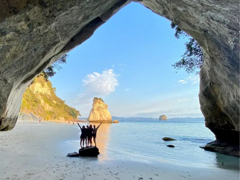
2. Mautohe Cathedral Cove Walk, Coromandel
Distance: 5 km
Route type: Return
Estimated time: 1 hour 30 minutes
Difficulty: Easy to intermediate
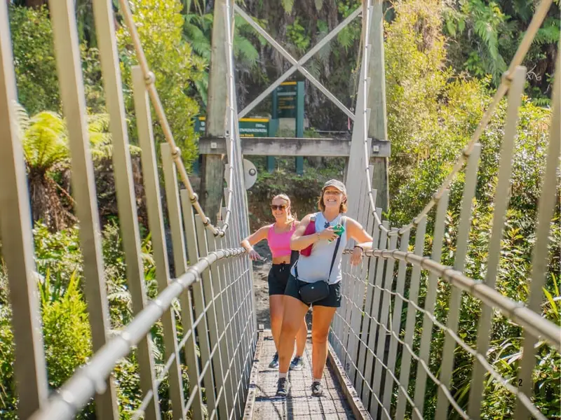
This Coromandel walk leads to one of New Zealand’s most photographed coastal arches, with side views across Te Whanganui-o-Hei Marine Reserve. Go early or outside peak summer if you want a quieter experience, and check conditions after heavy rain because the area can be affected by slips and rockfall.
See this on: Northern Voyager Route
3. Karangahake Windows Walk, Bay of Plenty
Distance: 2.5 km
Route type: Return
Estimated time: 1 hour
Difficulty: Easy short walk
This short walk packs in old gold mining tunnels, river views and historic remains from the Karangahake Gorge mining era. Bring a torch for the tunnels and allow extra time if you want to explore nearby historic trails.
See this on: North Island Escape
4. Karangahake Gorge Historic Walkway, Bay of Plenty
Distance: 2.5 km or 7 km
Route type: Return options
Estimated time: 45 minutes or 4 hours
Difficulty: Easy to intermediate
This trail follows the old railway line between Paeroa and Waihi, giving walkers a mix of gorge scenery, mining relics and railway history. Choose the shorter option if you want a quick stop, or take the longer return for a more complete Karangahake Gorge walk.
5. Taranaki Falls Walk, Tongariro National Park
Distance: 6 km
Route type: Loop
Estimated time: 2 hours
Difficulty: Easy to intermediate
This loop from Whakapapa Village is one of the best short hikes in Tongariro National Park. It passes volcanic landforms, tussock, forest and the 20-metre Taranaki Falls, making it a strong option when you want a shorter alternative to longer Tongariro hikes.
6. Lake Rotopounamu Track, Tongariro National Park
Distance: 5 km
Route type: Loop
Estimated time: 2 hours
Difficulty: Easy to intermediate
Lake Rotopounamu is a calm forest loop near Tūrangi, with lake-edge rest spots and native bush around the track. It is a useful option for travellers who want a gentler North Island hike near Tongariro without committing to alpine terrain.
See this on: Great North Voyage
7. Maungawhau / Mount Eden Summit Walk, Auckland
Distance: Short summit walk, distance varies depending on start point
Route type: Return or loop options
Estimated time: Around 30 minutes to 1 hour, depending on route and stops
Difficulty: Very Easy
Maungawhau / Mount Eden is one of the best easy hikes in Auckland, especially if you want a quick volcanic walk close to the city centre. The summit sits 143 metres above sea level and gives wide views across Auckland, the Waitematā Harbour and the volcanic crater, which is sacred and should not be entered.
See this before or after: Far North 4-Day Escape
Best Moderate Hikes in the North Island
8. Mount Manaia Track, Northland
Distance: 4 km
Route type: Return
Estimated time: Around 2 hours
Difficulty: Moderate fitness, steep climb
Mount Manaia is short but steep, with plenty of steps through regenerating native bush. The payoff is a strong viewpoint over Whangārei Harbour, Bream Head and the Hen and Chicken Islands.
9. The Pinnacles Walk, Coromandel
Distance: Varies by route
Route type: Return or circuit
Estimated time: 6 to 7 hours 30 minutes return via Webb Creek Track, or 7 to 8 hours 30 minutes as a circuit
Difficulty: Intermediate to advanced
The Kauaeranga Kauri Trail, often called The Pinnacles Walk, follows an old packhorse route used by kauri bushmen. It is one of the Coromandel’s classic longer day hikes, with a final climb to the Pinnacles lookout for wide peninsula views.
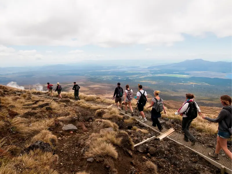
10. Tongariro Alpine Crossing, Ruapehu
Distance: 19.4 km
Route type: One way
Estimated time: 7 to 8 hours
Difficulty: Medium, with challenging climbs
The Tongariro Alpine Crossing is one of the most famous day hikes in New Zealand, crossing volcanic terrain, crater lakes and exposed alpine sections. It is a serious full-day walk, and in winter it is only suitable for people with mountaineering skills and equipment.
See this on: Ultimate North Island
11. Tama Lakes Track, Tongariro National Park
Distance: 17.6 km
Route type: Return via same track
Estimated time: 5 to 6 hours to Lower Tama Lake
Difficulty: Intermediate tramping track
Tama Lakes is a strong choice if you want a longer Tongariro day hike without the one-way logistics of the Alpine Crossing. The track starts from the Taranaki Falls route and moves into exposed volcanic country, with the Upper Tama Lake side trip requiring alpine care in snow or ice.
12. Putangirua Pinnacles Track, Wairarapa
Distance: Varies by route
Route type: Return or loop options
Estimated time: Around 2 to 4 hours, depending on route
Difficulty: Moderate
The Putangirua Pinnacles track leads into a dramatic valley of eroded rock formations near Cape Palliser. It is a compact hike with a big visual payoff, especially for travellers heading through the lower North Island.
13. Pouākai Crossing, Taranaki
Distance: Around 19 km
Route type: One way
Estimated time: Full day
Difficulty: Backcountry tramp
The Pouākai Crossing takes hikers across a changing Taranaki landscape of forest, wetlands, boardwalks and alpine views. DOC describes it as a backcountry tramp with rough, muddy, wet or icy sections, so it needs proper footwear, weather checks and a realistic plan.
14. Mount Maunganui Summit Track, Bay of Plenty
Distance: Around 3.8 km
Route type: Return
Estimated time: Around 1 to 1.5 hours
Difficulty: Moderate
The Mauao summit tracks are popular for a reason: they are close to town, easy to fit into a travel day and deliver strong views over Tauranga, the beach and harbour. Expect a steady climb rather than a remote wilderness walk.
Best Challenging and Multi-Day Hikes in the North Island
15. Cape Brett Track, Northland
Distance: 16 km
Route type: One way
Estimated time: 8 hours one way
Difficulty: Advanced
Cape Brett is a rugged coastal hike through native and regenerating bush, with steep terrain and exposed cliff sections. Many walkers stay at Cape Brett Hut or arrange boat transport, but the track still requires high fitness and proper preparation.
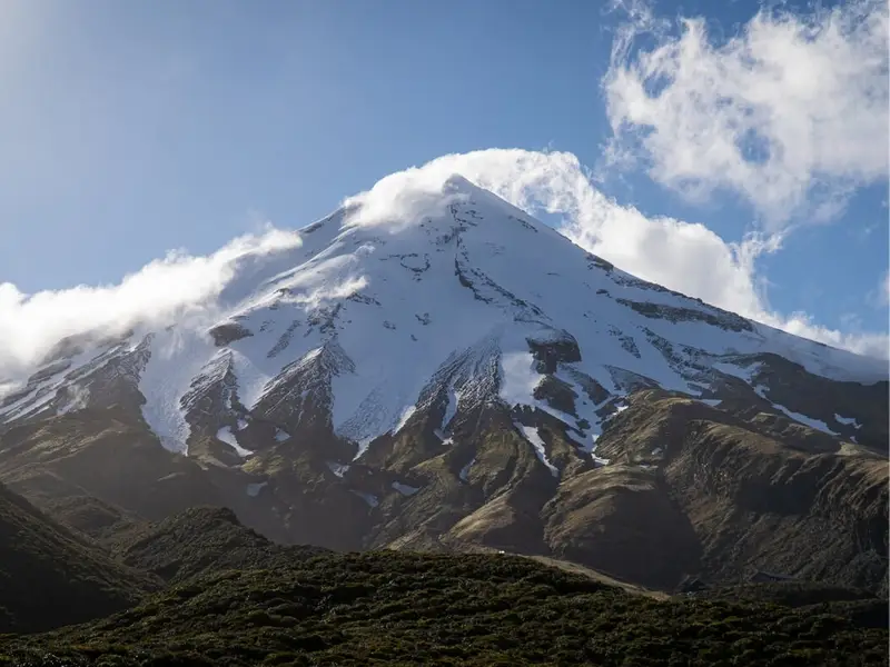
16. Taranaki Maunga Summit Climb, Taranaki
Distance: 6.3 km one way
Route type: Return via same track
Estimated time: 5 to 6 hours up, 3 to 4 hours down
Difficulty: Advanced tramping track / expert route
This is one of the most demanding North Island day hikes, climbing from forest and scree to the summit of Taranaki Maunga. DOC notes that snow and ice are common from May to December, when mountaineering experience and equipment are required.
17. Lake Waikaremoana Great Walk, Te Urewera
Distance: 46 km
Route type: One way
Estimated time: Multi-day
Difficulty: Great Walk / backcountry experience
Lake Waikaremoana is a quieter, more remote Great Walk through Te Urewera. It suits hikers who want forest, lake views and a deeper backcountry feel rather than a quick viewpoint walk.
18. Tongariro Northern Circuit, Tongariro National Park
Distance: 43 km
Route type: Circuit
Estimated time: 3 to 4 days
Difficulty: Great Walk
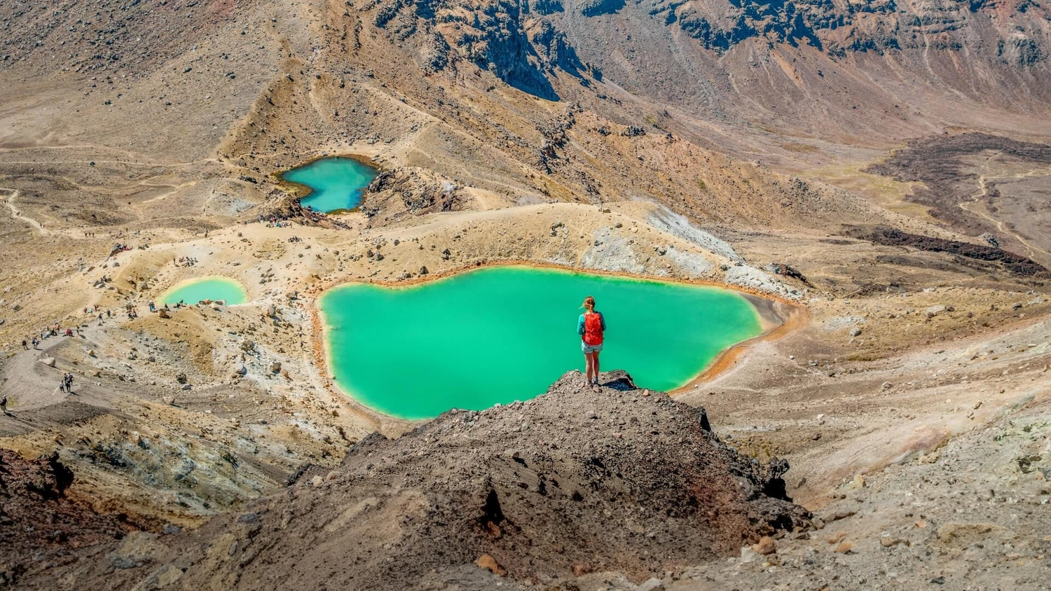
This Great Walk circles through the volcanic heart of Tongariro National Park, passing alpine meadows, glacial valleys, native beech forest and emerald-coloured lakes. It starts and finishes in Whakapapa Village, which makes logistics easier than some one-way multi-day hikes.
19. Round the Mountain Track, Tongariro National Park
Distance: Around 73 km
Route type: Circuit
Estimated time: 4 to 6 days
Difficulty: Advanced tramping track
Round the Mountain Track circles Ruapehu and gives experienced hikers a longer, rougher alternative to the Tongariro Northern Circuit. It is best suited to trampers with backcountry skills, changeable weather gear and confidence on more remote terrain.
20. Aotea Track, Great Barrier Island
Distance: Around 25 km
Route type: Circuit
Estimated time: 2 to 3 days
Difficulty: Intermediate to advanced
The Aotea Track crosses forest, ridgelines and volcanic terrain on Great Barrier Island. It is a strong multi-day option for hikers who want something wilder than a mainland day walk, with hut stays and big Hauraki Gulf views.
21. Te Whara Track, Whangārei Heads
Distance: Around 7.5 km
Route type: One way
Estimated time: 5 to 6 hours
Difficulty: Advanced
Te Whara Track follows an old Māori trail across the Bream Head Scenic Reserve. It is steep, rooty and demanding in places, but the ridge views make it one of Northland’s standout hikes for confident walkers.
Best Easy Hikes in the South Island
22. Kaikōura Shoreline Walk, Canterbury
Distance: 4.4 km
Route type: One way
Estimated time: 50 minutes
Difficulty: Easy
This coastal walk begins near Point Kean and follows the shoreline towards South Bay, with chances to spot seals and seabirds from a safe distance. It is a good South Island hike for travellers who want wildlife, ocean views and a short walking window.
23. Fox Glacier Te Moeka o Tuawe Valley Walk, West Coast
Distance: 2.6 km
Route type: Return
Estimated time: 1 hour
Difficulty: Easy
This short glacier valley walk gives a close look at the landscape shaped by Fox Glacier. Track access can change due to ice collapse, flooding or rockfall, so check the latest conditions before you go.
24. Lake Matheson / Te Ara Kairaumati Walk, West Coast
Distance: 4.4 km
Route type: Loop
Estimated time: 1 hour 30 minutes
Difficulty: Easy to intermediate
Lake Matheson is one of the best short walks on the West Coast, especially in still conditions when the water reflects Aoraki/Mount Cook and the Southern Alps. The loop is gentle, accessible and easy to pair with a Fox Glacier stop.
25. Blue Pools Track, Mount Aspiring National Park
Distance: 3 km
Route type: Return
Estimated time: 1 hour
Difficulty: Easy
Blue Pools Track is a short forest walk near Makarora leading to clear blue water where the Blue River meets the Makarora River. It is a quick, high-reward stop between Wānaka and the West Coast, but check access before visiting because this area has had bridge and maintenance work in recent years.
26. Truman Track, Punakaiki
Distance: Short walk
Route type: Return
Estimated time: Around 15 to 30 minutes
Difficulty: Easy
Truman Track is a compact West Coast walk through coastal forest to a sea-edge viewpoint near Punakaiki. It is ideal if you want a short leg-stretcher near Pancake Rocks without committing to a longer trail.
27. Wainui Falls Track, Abel Tasman National Park
Distance: Around 3.4 km
Route type: Return
Estimated time: Around 1 hour 20 minutes
Difficulty: Easy
Wainui Falls is a forest and river walk near the northern end of Abel Tasman National Park. It is a great option if you want a waterfall hike without needing water taxis or a full coastal track plan.
28. Hooker Valley Track, Aoraki/Mount Cook National Park
Distance: Currently listed as 4.3 km return while bridge work is underway; usually known as a longer valley walk
Route type: Return
Estimated time: Currently 1 hour return
Difficulty: Easy to intermediate
The Hooker Valley Track is one of the most searched hikes in New Zealand, known for alpine views around Aoraki/Mount Cook National Park. DOC currently lists the track as shortened to Kakīroa/Mount Sefton View Lookout while a new bridge is being built, so this one needs a fresh check before publishing or visiting.
29. Queenstown Hill Time Walk, Queenstown
Distance: Listed by Tourism New Zealand as 500 m
Route type: Return
Estimated time: 3 hours return
Difficulty: Medium, with a challenging incline
Queenstown Hill is a classic town-based hike with a steady climb through forest to open views across Lake Wakatipu and the surrounding ranges. It is a strong first hike in Queenstown because it starts close to town and still feels like a proper leg burner.
30. Mount Iron Track, Wānaka
Distance: Around 4.5 km
Route type: Loop
Estimated time: Around 1.5 hours
Difficulty: Easy to moderate
Mount Iron is one of Wānaka’s most accessible short hikes, with a steady climb to views over the lake, town and surrounding mountains. It is a good sunrise or late-afternoon option when you want something active without taking a full day.
31. Moke Lake Loop Track, Queenstown
Distance: Around 6.5 km
Route type: Loop
Estimated time: 2 to 3 hours
Difficulty: Easy to moderate
Moke Lake Loop is a relaxed lakeside hike just outside Queenstown, with mountain views and a quieter feel than many town-centre trails. It works well for travellers who want a scenic half-day walk without a big alpine climb.
Best Moderate Hikes in the South Island
32. Mount Robert Circuit, Nelson Lakes National Park
Distance: 9 to 10 km
Route type: Loop
Estimated time: 4 to 5 hours
Difficulty: Medium
Mount Robert Circuit climbs above Lake Rotoiti and moves between forest, open tops and alpine plants. Tourism New Zealand lists it as a 10 km, 5-hour return walk, while DOC’s Nelson Lakes brochure lists 9 km and 4 hours, so use the longer estimate when planning.
33. Mount Stokes Track, Marlborough Sounds
Distance: 6 km
Route type: Return
Estimated time: Half-day return
Difficulty: Medium, with steep sections
Mount Stokes is the highest point in the Marlborough Sounds and gives hikers a tougher half-day climb through forest to sub-alpine terrain. On clear days, the summit views stretch across the Sounds, Picton, Nelson and towards the North Island.
34. Rob Roy Track, Mount Aspiring National Park
Distance: 10 km
Route type: Return via same track
Estimated time: 3 to 4 hours
Difficulty: Easy to intermediate
Rob Roy Track is one of the best half-day hikes near Wānaka, leading into an alpine valley below glaciers, cliffs and waterfalls. DOC notes avalanche risk on the upper section from May to November, so seasonal conditions matter.
35. Key Summit Track, Fiordland National Park
Distance: 3.4 km one way
Route type: Return via same track
Estimated time: 3 hours
Difficulty: Intermediate tramping track
Key Summit branches off the Routeburn Track from The Divide on the Milford Road. It is a strong Fiordland day walk for travellers who want alpine tarns, mountain views and a taste of Great Walk terrain without doing the full Routeburn.
36: Sealy Tarns Track, Aoraki/Mount Cook National Park
Distance: Around 5.8 km
Route type: Return
Estimated time: 3 to 4 hours
Difficulty: Moderate to hard
Sealy Tarns is famous for its long staircase climb above the Hooker Valley. It is short on distance but heavy on elevation, making it best for hikers who want a sharp climb and big Aoraki/Mount Cook National Park views.
37. Bealey Spur Track, Arthur’s Pass National Park
Distance: Around 12 km
Route type: Return
Estimated time: 4 to 6 hours
Difficulty: Moderate
Bealey Spur is a steady Arthur’s Pass hike with views across braided river valleys and surrounding peaks. Compared with the tougher routes nearby, it is a more approachable way to experience high-country terrain.
38. Isthmus Peak Track, Wānaka / Hāwea
Distance: 16 km
Route type: Return
Estimated time: 5 to 7 hours
Difficulty: Advanced
Isthmus Peak is a long, steady climb between Lake Wānaka and Lake Hāwea. DOC lists it as a 16 km return alternative when conditions are poor for more technical tracks in the wider Mount Aspiring area.
39. Roys Peak Track, Wānaka
Distance: 16 km
Route type: Return
Estimated time: 5 to 6 hours
Difficulty: Advanced
Roys Peak is one of the most famous South Island hikes thanks to its big lake and mountain views above Wānaka. It climbs more than 1,200 metres vertically, so start early, carry layers and avoid underestimating the descent.
40. Ben Lomond Track, Queenstown
Distance: 11 km return from the DOC-listed summit track, or 14 km return from the Tiki Trail start
Route type: Return
Estimated time: 6 to 8 hours to the summit from Queenstown
Difficulty: Advanced
Ben Lomond is Queenstown’s big day hike, climbing from town into alpine terrain with a serious 1,438-metre elevation gain when done from Queenstown. It is demanding, exposed and weather-dependent, but it is one of the best hikes in Queenstown for confident walkers.
41. Avalanche Peak Route, Arthur’s Pass National Park
Distance: Varies by route
Route type: Return or loop options
Estimated time: Full day
Difficulty: Advanced / expert route
Avalanche Peak is a steep alpine route from Arthur’s Pass Village, with marked sections above the bushline and exposed terrain near the summit. DOC advises turning back in poor visibility or if the track feels too difficult before the alpine section.
Best Challenging and Multi-Day Hikes in the South Island
42. Abel Tasman Coast Track, Abel Tasman National Park
Distance: 60 km
Route type: One way
Estimated time: 3 to 5 days
Difficulty: Great Walk
The Abel Tasman Coast Track is one of the most accessible multi-day hikes in New Zealand, with beaches, forest and water taxi options along the route. It is a good Great Walk for travellers who want flexibility rather than a single fixed start-to-finish push.
43. Heaphy Track, Kahurangi National Park
Distance: 78.4 km
Route type: One way
Estimated time: 2 to 6 days
Difficulty: Great Walk
The Heaphy Track crosses a huge range of landscapes, from tussock downs and forest to nīkau palms and West Coast surf. It is one of the longest Great Walks and suits hikers who want variety over several days.
44. Paparoa Track, West Coast
Distance: 55 km
Route type: One way
Estimated time: 2 to 3 days
Difficulty: Great Walk
Paparoa Track moves through rainforest, limestone karst and alpine tops between the Blackball and Punakaiki areas. It is one of New Zealand’s newer Great Walk experiences and can be hiked or mountain biked.
45. Routeburn Track, Mount Aspiring and Fiordland National Parks
Distance: 32 km
Route type: One way
Estimated time: 2 to 4 days
Difficulty: Great Walk
The Routeburn is short by Great Walk standards, but it delivers a huge alpine experience across the Southern Alps / Kā Tiritiri o te Moana. It links the Queenstown and Fiordland sides, so transport planning is important.
46. Kepler Track, Fiordland National Park
Distance: 60 km
Route type: Circuit
Estimated time: 3 to 4 days
Difficulty: Great Walk
The Kepler Track starts and finishes near Te Anau, making it one of the easier Great Walks to manage logistically. It moves from lakeside beech forest to exposed alpine tops around Mt Luxmore, so weather can make the high sections feel much harder.
47. Milford Track, Fiordland National Park
Distance: 53.5 km
Route type: One way
Estimated time: 4 days
Difficulty: Great Walk
The Milford Track is one of New Zealand’s most famous multi-day hikes, travelling from the head of Lake Te Anau to Milford Sound / Piopiotahi. Expect rainforest, rivers, waterfalls, mountain passes and the kind of Fiordland weather that makes waterproof gear non-negotiable.
48. Hump Ridge Track, Southern Fiordland
Distance: 60 km
Route type: Loop
Estimated time: 3 days
Difficulty: Great Walk
The Hump Ridge Track combines coastline, forest and mountain sections near Tuatapere in southern Fiordland. It is a loop, which makes transport simpler than several one-way Great Walks.
49. Rakiura Track, Stewart Island / Rakiura
Distance: 32 km
Route type: Circuit
Estimated time: 3 days
Difficulty: Great Walk
Rakiura Track is a southern island hike through forest, coastline and bird-rich terrain near Halfmoon Bay. It is a good Great Walk for travellers who want a quieter, more remote feel without a huge distance.
50. Mueller Hut Route, Aoraki/Mount Cook National Park
Distance: Around 10.4 km return
Route type: Return
Estimated time: 6 to 8 hours return, or overnight with hut booking
Difficulty: Advanced
Mueller Hut Route is a steep alpine climb above Aoraki/Mount Cook Village, often done as either a long day hike or an overnight hut trip. It requires strong fitness, proper alpine preparation and careful weather judgement, especially outside summer.
How to Choose the Best New Zealand Hike for Your Trip
If you are visiting New Zealand for the first time, do not try to hike everything. Pick your trails around your route, your fitness and the kind of landscapes you most want to experience.
For volcanoes, focus on Tongariro and Taranaki. For alpine views, look at Aoraki/Mount Cook, Wānaka, Queenstown and Arthur’s Pass. For beaches and coastal tracks, Abel Tasman, Northland, Kaikōura and the Coromandel are strong choices. For multi-day hiking, the Great Walks are the easiest place to start because the tracks, huts and booking systems are clearly managed.
The best hike in New Zealand is not always the hardest one. Sometimes it is the walk that fits your day, leaves enough energy for the rest of your trip and gives you a proper sense of where you are.
Explore New Zealand’s Best Hikes with Wild Kiwi
Want to experience New Zealand’s mountains, lakes, coastlines and national parks without piecing the whole trip together yourself? Wild Kiwi trips are built for travellers who want adventure, local knowledge and a small-group way to see more of Aotearoa.
From North Island volcanic landscapes to South Island alpine trails, our New Zealand tours make it easier to reach the places that belong on your travel list. Bring your hiking shoes, pack a good rain jacket and come ready for the kind of days you will talk about long after the trip ends.
Explore Wild Kiwi New Zealand trips and book your adventure today!
FAQs About Hiking in New Zealand
What is the best hike in New Zealand?
The Tongariro Alpine Crossing is often called one of the best day hikes in New Zealand because of its volcanic landscapes, crater lakes and full-day challenge. For multi-day hiking, the Routeburn Track, Milford Track, Abel Tasman Coast Track and Kepler Track are among the most popular Great Walks.
What is the most famous hike in New Zealand?
The Tongariro Alpine Crossing is probably the most famous day hike in New Zealand. The Milford Track is one of the most famous multi-day hikes and has a long reputation as a classic New Zealand Great Walk.
What are the best hikes in the North Island?
Some of the best North Island hikes include the Tongariro Alpine Crossing, Tama Lakes Track, Taranaki Falls, Pouākai Crossing, Mount Manaia, Cape Brett Track, Rangitoto Summit Track and The Pinnacles Walk.
What are the best hikes in the South Island?
Some of the best South Island hikes include Hooker Valley Track, Roys Peak, Ben Lomond, Rob Roy Track, Key Summit, Abel Tasman Coast Track, Routeburn Track, Kepler Track, Milford Track and the Rakiura Track.
What is the best easy hike in New Zealand?
Lake Matheson, Taranaki Falls, Rangitoto Summit, Blue Pools Track and Wainui Falls are good easy or easier hiking options. The best choice depends on your route and the current track conditions.
What is the hardest hike in New Zealand?
New Zealand has many difficult alpine and backcountry routes. Among the hikes in this guide, Taranaki Maunga Summit Climb, Avalanche Peak, Ben Lomond, and Mueller Hut Route are some of the more demanding options.
Can beginners hike in New Zealand?
Yes, beginners can hike in New Zealand if they choose suitable tracks and check conditions before setting out. Start with short walks, easy walking tracks or well-formed day hikes before attempting alpine routes or multi-day tramps.
What is the best time of year to hike in New Zealand?
The main hiking season is usually late spring through early autumn, roughly November to April. Alpine tracks can still have snow, ice or fast-changing weather, so always check DOC alerts, forecasts and local advice before heading out.
Do I need hiking boots for New Zealand?
For short, easy walks, comfortable walking shoes may be enough. For longer hikes, muddy tracks, steep terrain, alpine routes or multi-day tramps, hiking boots or sturdy trail shoes are strongly recommended.
Are New Zealand Great Walks worth it?
Yes, the Great Walks are worth it if you want well-known multi-day hikes with maintained tracks, huts and clear booking systems. They do require planning, and popular tracks like Milford, Routeburn and Abel Tasman can book out early.
Do I need to book New Zealand hikes in advance?
Day hikes usually do not need booking, although transport or parking rules may apply. Great Walk huts and campsites often need advance booking, especially during the main walking season.
Is hiking in New Zealand safe?
Hiking in New Zealand is safe when you choose tracks that match your fitness, check the weather, carry the right gear and avoid taking risks in alpine or river conditions. Weather can change quickly, so preparation matters even on popular trails.


